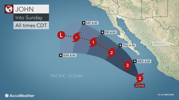
Hurricane John is expected to strengthen and impact parts of Mexico this week. Former Tropical Storm Ileana was absorbed into John on Tuesday; however, remnant moisture caused downpours in southern Baja California into Tuesday evening.
Accuweather.com reported that less than ideal beach conditions are expected as downpours can result in brief flash flooding and travel disruptions. Rough surf and rip currents will also be a concern.
While impacts from Ileana were ending Tuesday night, John is expected to continue strengthening into a powerful hurricane as it tracks parallel to the Mexico coastline into Friday.
John is expected to become a major hurricane with sustained winds over 200 km/h (125 mph).
Fortunately, the dangerous cyclone will remain offshore and should bring no risk for damaging winds to Mexico through Friday.
John will still pose a serious risk to life as it produces dangerous seas and surf along southern- and western-facing coasts of Baja California from Wednesday into Friday.
The outer edges of John could skirt southern Baja California on Wednesday before the storm turns more toward the northwest and moves away from land.
Localized downpours are the main concern during this time. Outdoor plans may need to be altered due to the quickly changing weather.
The storm will weaken as it continues to track to the northwest, passing west of Baja California late this week.
Farther west, Tropical Storm Kristy formed on Tuesday morning. This storm is expected to meander to the west then north as it strengthens this week, posing no threat to land.
John is forecast to outlast and out-strengthen Ileana and move far enough away from the coast of Mexico to allow waves to propagate well to the north.
John is likely to be in a position to send waves northward to the beaches and coastal waters of Southern California as early as Friday, but more likely during the weekend.
Source: Accuweather.com


